SpotRotterdam - Rotterdam
In a nutshell
Do you want to enjoy Rotterdam spaciously, comfortably and safe?
Thanks to SpotRotterdam, imagined and created by the municipality of Rotterdam, you can do so a lot easier than before. With SpotRotterdam you get a live overview of where there is a crowd, or on the contrary where things are quiet. Our own Rotterdam busyness-meter, nice and relaxed, right!
Buttah, how does it work?
Simple!
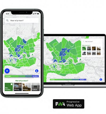
With SpotRotterdam you search for categories, like parks, bars or theatre, in your favourite place in town or your desired area. SpotRotterdam works on your smartphone as well as on your computer.
If your place or area is shown in green, then few people are present. Green with blue dots means there is a fair number of people. Dark blue means it is quite crowded.
Simple!
What makes the service user-centric?
The whole idea of the busyness app is the user and his/her choices on mobility and health in our city. The app offers a digital (only) solution on the mobile ecosystem (android and iOS) so without any digital divide most of the people visiting Rotterdam would be able to reach the information on their destinations or preferred areas provided in the app, with real time information.
What impact has the service had?
Inhabitants, visitors, people looking for recreation are able to make their own decisions on the value of busyness they are comfortable with. During the COVID-19 pandemic this is not just for the fun or relaxation, but also for our health and that of others. Also, the visitors get to know new places in Rotterdam by going to places and areas visited and thus experienced less.
Besides this direct effect SpotRotterdam also taught us lessons on how to connect various types of datasets into our public services. In this case the data of BAG (buildings, addresses and buildings), of Resono Data (a company that uses aggregated data of users that have agreed to their data use in various apps) and Open Street Map (GIS-data, linking to addresses, phone numbers etc in the specific areas on the map)
How was the service co-created?
SpotRotterdam was designed in a cooperation between our Data Science team (research department) and Total Design (external party). This was requested by our vice mayor Barbara Kathman and smart city program manager Frank Vieveen of city development department. Due to the pandemic we were not able to connect to the end users in this process. During various iterations over a period of close to half a year the app was made ready to launch. The launch came with both communication and marketing as well as with interest from bot local as well as national media. After the useage of the app started picking up more smaller changes were made based on the feedback from the end users.